The Republic of Poland has a turbulent history – as do its many place names. Hardly any town or village has only one, which makes the matter very complicated, especially for historical research.
Introduction
Text
Most of us take place names for granted and see them as unambiguous. We use them to explain where we come from or where we want to go, for navigation, or we link certain events with them. When dealing with the past, however, place names are often charged with additional meaning. This can be illustrated by particularly striking examples. Thus, in the case of Auschwitz and Oświęcim, we use two names – one historical and the other current – for the same locality, but by our choice of name we either imply the context of a National Socialist extermination camp or refer to a modern-day city in Lesser Poland. Especially when it comes to the history of Poland, which is so marked by wars and border shifts, hardly any place has only one name. For the areas that changed their national affiliation several times between Prussia and Poland during the interplay of those powers, it is often assumed today that there are up to three name variants that must be considered. For historians, the matter is more complex, because there is always the question of which name variant was chosen by the various populations in respective eras. The challenge will be illustrated by episodes from three periods of shared history.
The role of place names in the Prussian territorial state
Text
The need for an unambiguous definition of geographical objects presupposes a system that must be able to retrieve and unambiguously assign these same objects across the boundaries of a local space. In Prussia, this need arose with the development of the early modern administrative state. In 1715, under Frederick William I, the Generalhufenschoß Generalhufenschoß A basic tax introduced in 1715 under Friedrich Wilhelm I. It replaced many individual regulations and taxed all landowners. When establishing it, various information was collected and the amount of tax also depended on, for example, the quality of the land.   was introduced in the 
Kingdom of Prussia
dan. Kongeriget Preussen, pol. Królestwo Prus, deu. Königreich Preußen

The Kingdom of Prussia existed from 1701 to 1918 and was reigned by the Hohenzollern dynasty. The country was an absolute monarchy from its founding until 1848 and a constitutional monarchy from 1848 until its dissolution. The capital of the Kingdom of Prussia was Berlin. The land was inhabited by about 40 million people. After the November Revolution of 1918 and the abdication of Wilhelm II, the Kingdom dissolved and formed the Free State of Prussia.

 (East Prussia): a land tax that was to be paid centrally by all subjects. For its implementation, Prussian officials needed something that today would be called data. They recorded, among other things, the quality and size of estates, as well as the names of the owners and the places. The place name thus initially served to locate a piece of land to be taxed. In 1718, the Prussian administration also introduced a law prohibiting the change of place names without permission, having recognized that the tax system depended on names not being changed without the consent of the legislature. Or, to put it another way, a system that is not designed to record or capture constant change is forced to put a stop to change.
In the course of the 18th century, Prussia annexed large parts of what is now Poland – including in the Silesian Wars Silesian Wars The Silesian Wars refers to three conflicts between the Kingdom of Prussia and the Habsburg monarchy. Already during the first war (1740-1742) Prussia secured most of Silesia, the second war (1744-1745) could not change this. The third war (1756-1763), was the main conflict of the Seven Years War on the European mainland. After the third war, the surrender of Silesia was officially confirmed. (1740-1763), as well as during the partitions of Poland-Lithuania partitions of Poland-Lithuania In the course of three partitions in 1772, 1793 and 1795, Poland-Lithuania was divided between the Russian Empire, Prussia and the Habsburg Monarchy and disappeared from the political map of Europe as a sovereign state until 1918. (1772-1795). The Prussian king introduced the same or similar tax systems in the former Polish territories, for example in the province of West Prussia in 1772, and here too, with a time lag, a place name law in 1775.
Diversity through uniformity
Text
The new province of West Prussia first had to be opened up geographically. This was done with the Friderizianische Landesaufnahme Friderizianische Landesaufnahme Designates a map series that was created in 1772 and 1773. With this, the Kingdom of Prussia wanted to create a basis for the introduction of the Generalhufenschoß tax in West Prussia. , a comprehensive land survey carried out in 1772/73. The existing language barriers in the region posed a particular challenge – less than 50% of the proportion of West Prussia was German-speaking. Accordingly, it was very difficult to collect data, including place names. The officials and surveyors, most of whom spoke only German, tried to record the place names in writing, based on the pronunciation of the native population. The resulting classification cadaster classification cadaster The compilation of all necessary information for taxation. The resulting files were kept by district and provided all the information necessary to set the tax for each property in the district. illustrates the procedure. In the section for the district of Inowraclaw (Pol.: Inowrocław) not only the name of the district itself varies in spelling, appearing, for example, as Inowratzlaw, but in general the spellings of all place names are very diverse. The village of Lonkoczino, as it is listed in the register, can also be found in the cadaster under the spellings Lonkoczin, Lonckortschin, Lonkortschin, and Longkortschin. The officials did not use a Polish spelling of the place name – today it would be Łąkocin – and Polish diacritics were not used either.
Text
In addition to these variants of place names, new versions appeared, as mapmakers of the time also tried to render the names according to their understanding. On one map section of the Schroettersche Landesaufnahme, a detailed map series of East and West Prussia produced in the years 1796-1802, the place name Lonkocin can be found, which is yet another spelling of the name. Both Prussian officials and mapmakers showed a similar approach. Places were usually not renamed, but the spelling of place names was changed. There was no standardization of spelling as we would expect today. The legal situation created by the Prussian administrative state was designed only for the functioning of the tax system. Uniformity in the pronunciation of place names was initially sufficient for Prussian officials. This resulted in different forms for the same initial name, at least in way place names were spelt.
National movements and place names
Text
The German national movement that led to the founding of the German Empire in 1871 had an impact on many areas of politics and society. Subjects of a kingdom now also became citizens of a German nation-state, and the eastern provinces of Prussia became the east of the German Empire. The German Empire defined a national language and demarcated the majority from the minorities. Place names also became a means of national legitimacy, and landowners and state bodies had an increasing influence on them. Some places were renamed, especially with the aim of gradually erasing ' 'foreign-language elements' 'foreign-language elements' Foreign language elements are interpreted differently depending on the standards in force. In Prussian times, this was often understood to mean only names/parts of names that were unfamiliar to the 'German tongue'. In the Nazi period, on the other hand, all elements that were 'non-German' according to the respective actors were widely eliminated. For example, the prefix 'Wendish' was changed in all place names. There is no neutral/objective explanation of the term. from the now German national territory. In addition to creating completely new names, existing place names were also linguistically adapted. Variations of spelling were chosen that were familiar to Germans and foreign-sounding endings were changed. Generally, this process is called Germanization. Such processes sometimes occurred side by side and not uniformly. Thus, situations arose in which, for example, the name of a place differed from the name of its railroad station, while the name of the postal authority was spelt differently again.
After the First World War, an independent Polish state emerged again after more than a hundred years. The Second Polish Republic and the Weimar Republic found themselves in competition over the legitimacy of their national territories. This conflict was also conducted through place names, among other things. By the time the Nazis seized power in 1933, some places on the German side had been renamed four times , especially in the parts of Silesia that had remained German and in East Prussia. On the Polish side, too, numerous place names were renamed or restored. As a counterpart to Germanization, Polonization was established, which in turn was supposed to prove the Polish national claim to territory. Thus, on contemporary Polish maps, the spellings Łąkocin and Inowrocław can be found for the examples already mentioned. In the Second Republic of Poland, a ‘place name commission’ was even set up in 1934, a new authority that centrally regulated decisions on the naming, renaming, and use of official place names.
The Peak of Germanization
Text
Barely 20 years after regaining its sovereignty, however, the state was again divided between the German Reich and the Soviet Union. Territorial entities such as the 
Reichsgau Wartheland
pol. Okręg Warcki, pol. Okręg Rzeszy Kraj Warty, deu. Warthegau, deu. Wartheland, deu. Reichsgau Posen

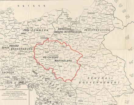
The Reichsgau Wartheland, also known as Warthegau, was a Nazi administrative district in occupied Poland that existed from 1939 to 1945. The Reichsgau was in large parts congruent with the historical landscape of Wielkopolska and had 4.5 million inhabitants. The capital was today's Poznań.

The almost six-year occupation period was characterized by the brutal persecution and murder of the Polish and Jewish population on the one hand and the targeted resettlement of German-speaking parts of the population on the other.

Image: „Map of the administrative division of the German Eastern Territories and the General Government of the occupied Polish territories as of March 1940“. Herder Institute for Historical Research on East Central Europe – Institute of the Leibniz Association, map collection, inventory no. K 32 II L 43, edited by Copernico (2022). CC0 1.0.

 emerged from the new distribution. Both in terms of its name and borders, this was a geographical region that had never before existed. In the following years a wave of Germanization spread through the annexed Polish territories, and the coexistence of differing place names caused unprecedented confusion.  From September 1939, the governor of Wartheland, Arthur Greiser, opened up the possibility to eliminate, on a wide scale, all traces of 'foreign place names' 'foreign place names' Foreign place names are interpreted differently depending on the standards in force. In Prussian times, this was often understood to mean only names/parts of names that were unfamiliar to the 'German tongue'. In the Nazi era, on the other hand, all elements that were 'non-German' according to the respective actors were widely eliminated. For example, the prefix 'Wendish' was changed in all place names. There is no neutral/objective explanation of the term. . He did this without coordinating with Berlin, where the Reich Ministry of the Interior, for its part, did not issue clear orders until December of that year. This marked the beginning of a confusion around supposedly official place names. Some places were renamed up to four times in the following years. In the end, in the Wartheland region, only the place names of the rural and urban districts were finally determined by the decree of the Reich Minister of the Interior of May 21, 1941 and September 12, 1942. In the district of Wollstein (Pol. Wolsztyn), for example, the district administrator changed 81 place names as early as September 1939. Among other things, place names such as Volkstreu (Loyal to the people) (Pol. Drzymałowo) were established, intended as an adaptation of the former Kaisertreu (loyal to the emperor), which had been in effect before 1918, to the National Socialist ideas. However, these place names were officially declared invalid by decree of the Reich Ministry of the interior in December 1939. Further renaming followed. For example, in the case of the village of Kielpin (Pol. Kiełpiny), the names Kilpiny, Kölpin, Kölpen and Breitenkelpin were also proposed and sometimes used by individual authorities.
Text
The map makers of the Nazi period had to point out the provisional nature of the place names and could not guarantee that all the names chosen were officially recognized. A comparison with the first map clearly shows the change in procedures from the 19th to the 20th centuries. A search for Inowrocław would be in vain. The place was first adapted in its spelling to the German in Inowrazlaw, before being renamed Hohensalza in 1904. In the Second Republic of Poland, it was called Inowrocław again and, as of 1939, Hohensalza once more. There is no Łąkocin listed on this map, as the village was renamed Grünwiese (Green meadow) in 1939. Overall, the map shows a much more 'German' picture in comparison with earlier versions. The Germanization of place names was joined by ideological National Socialist renamings from 1939 onward. Well-known examples are Gotenhafen for Gdynia and Litzmannstadt for Łódź. The map features, for example, a Gotendorf (Pol. Gocanowo). Not all renamings of the Nazi period are clearly recognizable as such, for example Grünholm (Ger. Chelmce, Pol. Chełmce) or the abovementioned Grünwiese.
De-Germanization and the Recovered Territories
Text
The end of the Second World War brought yet another change to the borders. Poland was shifted to the west. Especially in the so-called 'Recovered Territories' 'Recovered Territories' The former German eastern territories, including Gdansk, which had become part of the People's Republic after World War II, were referred to in Poland from 1945 as the "Recovered Territories" (Ziemie Odzyskane in Polish).  a process of mass renaming began. After 1945, the Polish government wanted all German traces removed. The turmoil of the post-war period and a lack of legal basis initially meant that various actors began the renaming process. These included the new local authorities and the Polish settlers who replaced the expelled German residents, as well as institutions such as the state railway or the so-called West Institute West Institute The Instytut Zachodni, located in Poznań, Poland was founded in 1945. In the first years after its establishment, it dealt mainly with Polish history in the western territories of Poland and was instrumental in the post-war renamings. The institute still exists today.   in Poznań. Thus, independently of each other and side by side, new place names were once again created here several times. In 1946, an official place name commission began to operate. It initially dealt with the 'Recovered Territories'. The commission worked at full speed to implement this undertaking. In 1951, Stanisław Rospond published a directory of localities entitled “Słownik Nazw Geograficznych Polski Zachodniej i Północnej,”1  which listed a total of 32,138 new geographical names. However, the place names recorded by the commission – actually the only official ones – did not necessarily prevail within the population. Even some local authorities did not use them. For example, in 1946 the former Stolpmünde had been given the Polish name Ustka by the Place Names Commission, but the city administration called it Postomino, and according to the post office it was Nowy Slupsk. At the same time, the name Słupi ujście was also in circulation. The People's Republic of Poland sometimes resorted to ideological naming as well, a well-known example being the renaming of Katowice to Stalinogród in 1953.
One space, two maps
Text
With the Potsdam Conference  in 1945, the Allies placed German territories east of the Oder and Neisse rivers under Polish administration – but did not secure permanent property rights. Thus, Poland's leadership was interested in creating firm facts, among other things by polonizing place names as quickly as possible. The GDR recognized the new border as early as 1950 and used the Polish/official place names. The Federal Republic, on the other hand, did not recognize Poland's sovereignty over the territory and continued to use the official German place names that had applied until the outbreak of World War II. Since, from the West German point of view, the final legal status of the territories had not been clarified, it was possible for the People's Republic and the Federal Republic to publish differing official gazetteers and maps at the same time.
Text
The example of two maps from the 1950s shows – again with reference to the section around Inowrocław – how two completely different representations of the same area were used. While the Polish map lists only Polish place names, including once again Inowrocław, the German map continues to list the German names – but not the same as the previous map, since the renamings from the time of the Second World War were omitted. Thus, the place named Grünholm (Pol. Chełmce) on the last map example is called Chelmce on the German map. Hohensalza, on the other hand, which had been renamed in 1904, remains. However, it is already interesting to note on the German map that the depicted area did not belong to the Weimar Republic even in the interwar period.
The many place names – finding a balance
Text
The introduction of a centralized tax system in the Kingdom of Prussia made the unambiguous localization of geographical objects in space a necessity. Over time, the reasons and actors behind successive moves to name, rename, and standardize place names multiplied. The expansion of the railway network and the increased volume of mail meant that these actors also had to be able to unambiguously order space for themselves. The nationalization of society in the 19th century gave place names a further role and meaning. Now, their job was not only to unambiguously localize a place, but they should also express the affiliation to a certain nation state or nationality. All these processes led to an increased debate and to spatial concepts constructed side by side and at the same time, especially in the form of maps, plans or gazetteers. The idea, nowadays widespread, of three place names, i.e., an official Polish one as well as a surviving German one and a designation from the Nazi period, is a post-war construction. This is primarily intended to separate Nazi history from the rest of German history. For research purposes, far more names must be included in our consideration. Different spellings, hasty renamings, and different place names used side by side are only some of the factors that have to be considered. In addition, there are other forms of place names that have not been mentioned in this short essay, for example, numerous dialectal versions, which fell victim to the homogenizing will of nation-states, especially Polish and German politics relating to the respective national languages. In historical research any name forms are relevant. As long as they were used by contemporary witnesses, it is not possible to clearly assign sources to a space without a knowledge of them.
Text
English translation: William Connor

Siehe auch